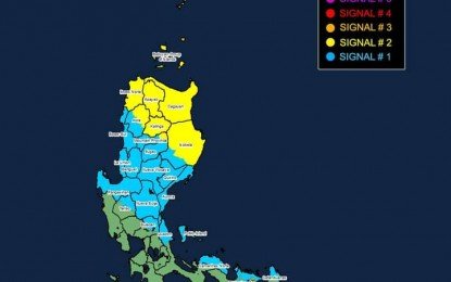
The Philippine Atmospheric, Geophysical and Astronomical Services Administration (PAGASA) has raised Tropical Cyclone Wind Signal (TCWS) No. 3 over extreme Northern Luzon as Typhoon “Leon” (international name Kong-Rey) continued to intensify on Wednesday.
Specifically, Batanes and the eastern portion of Babuyan Islands have been placed under TCWS No. 3, with strong to typhoon-force winds prevailing in those areas.
Leon was tracked at 395 kilometers east of Calayan, Cagayan as of 4 a.m. of Wednesday, according to PAGASA’s 5 a.m. bulletin. It packed maximum sustained winds of 165 kph near the center and gustiness of up to 205 kph.
The typhoon will bring gusty winds over Bataan, Metro Manila, Calabarzon, Mimaropa, Bicol Region, most of the Visayas, and Dinagat Islands.
PAGASA also warned of storm surges in parts of extreme northern Luzon.
“There is a moderate to high risk of life-threatening storm surge reaching 2 to 3 meters above normal tide levels in the next 48 hours over the low-lying or exposed coastal localities of Batanes and Cagayan including Babuyan Islands,” said PAGASA.
The weather bureau forecasts Leon reaching super typhoon category during its closest point of approach to Batanes possibly on Thursday.
The typhoon is forecast to exit the Philippine Area of Responsibility on Thursday night or Friday.
For Wednesday, Gale-force winds will prevail in areas under TCWS No. 2: the rest of Babuyan Islands, Cagayan, the northern and eastern portions of Isabela (Santo Tomas, Santa Maria, Quezon, San Mariano, Naguilian, Dinapigue, Delfin Albano, San Pablo, Ilagan City, Benito Soliven, Tumauini, Cabagan, Palanan, Quirino, Divilacan, Gamu, Mallig, Maconacon, Burgos, City of Cauayan, San Guillermo, Angadanan, Cabatuan, Luna, Reina Mercedes, Roxas, Aurora, San Manuel), Apayao, Kalinga, the northern and eastern portions of Abra (Tineg, Lacub, Malibcong, Lagayan, San Juan, Lagangilang, Licuan-Baay, Daguioman), the eastern portion of Mountain Province (Paracelis), and Ilocos Norte.
TCWS No. 1 is hoisted over the rest of Isabela, Quirino, Nueva Vizcaya, the rest of Mountain Province, Ifugao, Benguet, the rest of Abra, Ilocos Sur, La Union, Pangasinan, Nueva Ecija, Aurora, the northeastern portion of Tarlac (Camiling, San Clemente, Paniqui, Moncada, Anao, San Manuel, Pura, Ramos, Victoria, Gerona, Santa Ignacia, City of Tarlac, La Paz), the northern portion of Bulacan (Doña Remedios Trinidad, San Miguel), the northern portion of Quezon (Infanta, General Nakar) including Polillo Islands, Camarines Norte, the northern portion of Camarines Sur (Siruma, Tinambac, Lagonoy, Garchitorena, Caramoan), and the northern and eastern portions of Catanduanes (Pandan, Gigmoto, Bagamanoc, Panganiban, Viga, Baras, Caramoran). Strong winds will prevail in these areas.
(PHOTO FROM PAGASA)


