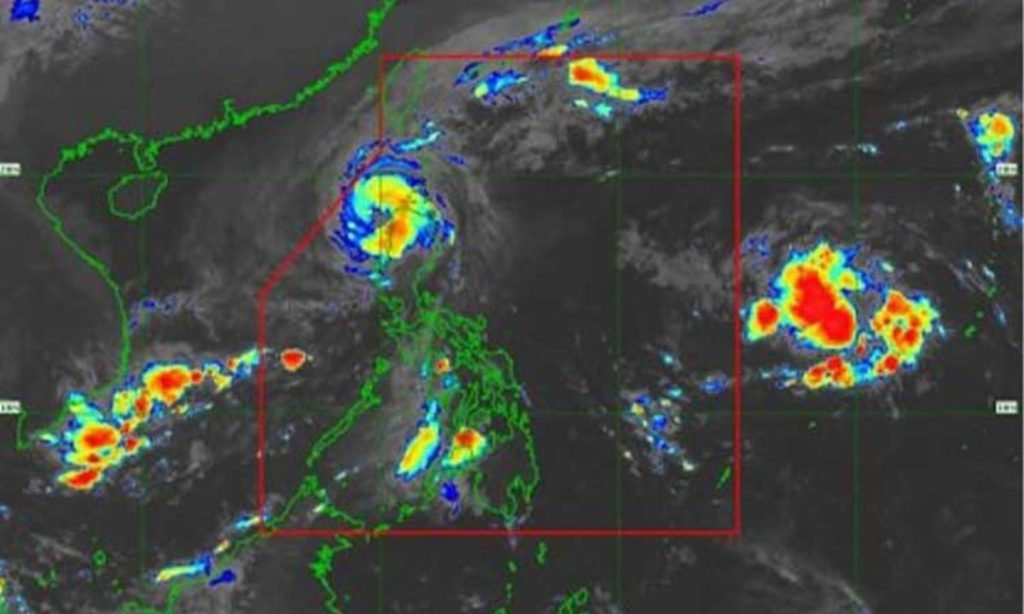
MANILA – Typhoon Marce (international name Yinxing) continues to weaken but more areas in Northern Luzon have been placed under Tropical Cyclone Wind Signal (TCWS) No. 4 based on the weather bureau’s 5 a.m. bulletin Friday.
The typhoon packs maximum sustained winds of 155 kph near the center and gustiness of up to 215 kph, according to the Philippine Atmospheric, Geophysical and Astronomical Services Administration (PAGASA).
It was located over the coastal waters of Pasuquin, Ilocos Norte as of 4 a.m.
Typhoon-force winds will be experienced in areas under TCWS No. 4: Ilocos Norte, the northernmost portion of Ilocos Sur (Sinait and Cabugao), the northern portion of Abra (Danglas, Lagayan, and Tineg),the northwestern portion of Apayao (Calanasan), and the northwestern portion of mainland Cagayan (Sanchez-Mira, Claveria, and Santa Praxedes).
TCWS No. 3 is hoisted over the southern and western portion of the Babuyan Islands (Fuga Island, Dalupiri Island, Calayan Island, and Camiguin Island), the northern and western portions of Cagayan (Piat, Santo Niño, Rizal, Aparri, Lasam, Camalaniugan, Buguey, Santa Teresita, Allacapan, Pamplona, Abulug, and Ballesteros), the rest of Apayao, the central portion of Abra (Lacub, San Juan, La Paz, Bangued, Langiden, San Quintin, Pidigan, Malibcong, Peñarrubia, Bucay, Licuan-Baay, Lagangilang, Dolores, Tayum, Sallapadan, and San Isidro), and the northern portion of Ilocos Sur (Santo Domingo, San Vicente, Santa Catalina, Bantay, San Ildefonso, City of Vigan, Caoayan, Santa, Narvacan, Nagbukel, Magsingal, and San Juan). Storm-force winds will prevail in these areas.
TCWS No. 2 is hoisted over the southern portion of Batanes (Mahatao, Uyugan, Basco, Ivana, and Sabtang), the rest of the Babuyan Islands, the rest of mainland Cagayan, the northern and western portions of Isabela (San Pablo, Santa Maria, Tumauini, Maconacon, Cabagan, Santo Tomas, Quezon, Mallig, Delfin Albano, Quirino, Gamu, Roxas, Burgos, Reina Mercedes, Luna, Aurora, San Manuel, San Mateo, and Cabatuan), the rest of Abra, Kalinga, Mountain Province, the northern portion of Ifugao (Alfonso Lista, Aguinaldo, Mayoyao, Banaue, and Hungduan), the northern portion of Benguet (Bakun and Mankayan), the rest of Ilocos Sur, and the northern portion of La Union (Sudipen, Bangar, Balaoan, Luna, Santol, and Bacnotan). Gale-force winds will prevail in these areas.
The rest of Batanes, the rest of La Union, Pangasinan, the rest of Ifugao, the rest of Benguet, the rest of Isabela, Quirino, Nueva Vizcaya, the northern and central portions of Aurora (Dilasag, Casiguran, Dinalungan, and Dipaculao), the northern portion of Nueva Ecija (Carranglan), and the northern portion of Zambales (Santa Cruz and Candelaria) were placed under TCWS No. 1 and will experience strong winds.
PAGASA said the northeasterly wind flow and the periphery of the typhoon will also bring strong to gale-force gusts across Batanes, Cagayan including the Babuyan Islands, Isabela, and Ilocos region.
“There is a high risk of life-threatening storm surge with peak surge heights exceeding 3 meters in the next 48 hours over the low-lying or exposed coastal localities of Batanes, Cagayan including Babuyan Islands, Isabela, Ilocos Norte, Ilocos Sur, and La Union,” PAGASA added.
Meanwhile, heavy to intense rains will prevail over Ilocos Norte, Ilocos Sur, Apayao, and Abra.
Moderate to heavy rains are forecast in La Union, Kalinga, and Cagayan.
Gale warning is hoisted over the seaboards of Northern Luzon. Sea travel is risky for all types or tonnage of vessels.
PAGASA expects Marce to weaken and exit the Philippine Area of Responsibility on Friday afternoon or evening. (PNA)


