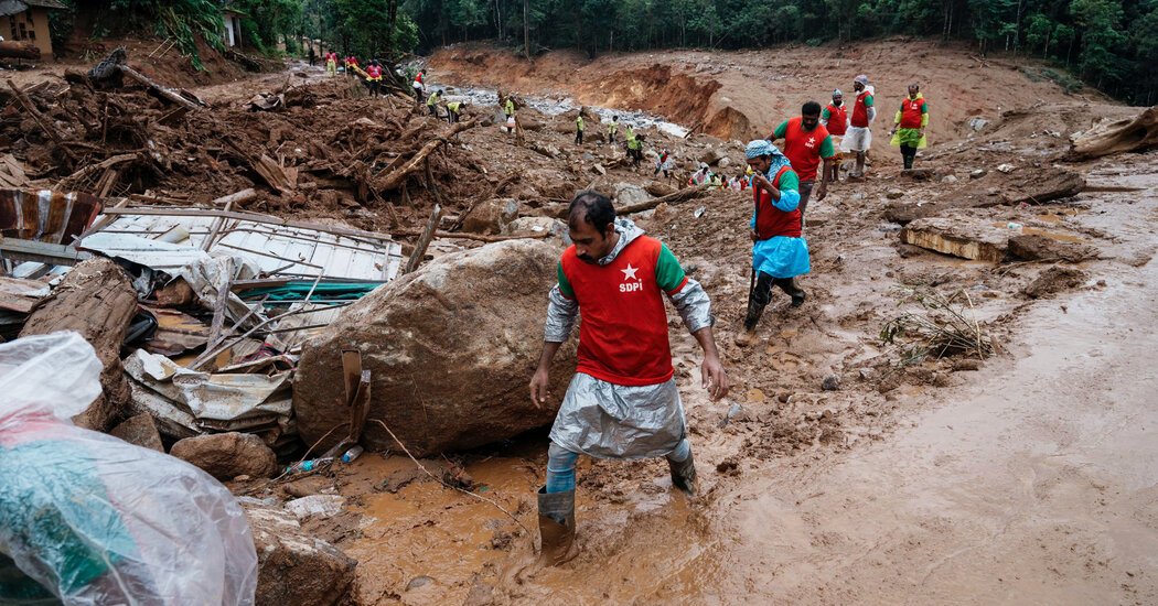
A sudden burst of rainfall on July 30 caused a cascade of landslides that buried hundreds of people in the mountainous Kerala region of southern India.
That downpour was 10 percent heavier because of human-caused climate change, according to a study by World Weather Attribution, a group of scientists who quantify how climate change can influence extreme weather. Nearly six inches, or 150 millimeters, of rain fell on soils already highly saturated from two months of monsoon and marked the third highest single-day rain event on record for India.
“The devastation in northern Kerala is concerning not only because of the difficult humanitarian situation faced by thousands today, but also because this disaster occurred in a continually warming world,” said Maja Vahlberg, a climate risk consultant at the Red Cross Red Crescent Climate Centre. “The increase in climate-change-driven rainfall found in this study is likely to increase the number of landslides that could be triggered in the future.”
In a state that is highly prone to landslides, the Wayanad district is considered the riskiest part. As of Tuesday, at least 231 people had died and 100 remained missing.
The Kerala landslides were the second extreme landslide event in July, following one in Ethiopia that killed 257 people. July was the second-worst month on record, after July 2019, with 95 landslide events that caused 1,167 fatalities, according to data maintained by Dave Petley, the vice-chancellor of the University of Hull. Together, they caused roughly one-third of the more than 3,600 deaths resulting from some 429 fatal landslides recorded this year, Dr. Petley said in an email.
Already, 2024 is an outlier, Dr. Petley posted to The Landslide Blog on Tuesday. He wrote that he could “only speculate on the likely underlying reasons for this very high incidence of fatal landslides,” but “the most likely cause continues to be the exceptionally high global surface temperatures, and the resultant increase in high intensity rainfall events.”
Global warming, caused primarily by the burning of fossil fuels, allows the atmosphere to retain more moisture, which contributes to the severity and intensity of rain. Heavier rain over a longer period of time can waterlog the soil, making a hillside heavier and more susceptible to slippage.
In Kerala, as elsewhere, potential adaptations could include reinforcing high-risk slopes, installing retaining structures, planting vegetation and protecting forest reserves. Other steps include encouraging people and businesses to avoid living in or developing commercial zones around high risk areas.
The study also found that prevention of disasters in hillside communities also required more rigorous risk assessments and improved early warning systems. While the Indian Meteorological Department issued an early warning in the days leading up the landslide, the alert was state-specific, making it difficult to determine which localities would be affected and should evacuate.
“Early warning systems are critical to saving lives,” said Ms. Vahlberg. “The implementation of landslide early warning systems in India is still in its infancy. But in response to recent disasters Kerala has intensified its development and rollout of such systems.”
How land is used and what it is covered with is another factor in landslide risk. Ms. Valberg said the link between landslides and changes in the way land is being used — for instance, when woodland is cleared, or buildings are constructed on a steep slope — required further study. Still, she said, in this case, quarrying for building materials, plus the 62 percent reduction in forest cover in the region, could have contributed to the slippage.
Bill Haneberg, a geological consultant and former Kentucky State Geologist, said land-use changes can contribute to an increased likelihood of landslides, not only from logging or quarrying but from agriculture and mining. A study he published this summer showed that during catastrophic flooding in Kentucky in 2022 that killed as many as 45 people, small tributaries immediately adjacent to mountaintop-removal coal mines had up to 150 percent more water than there might have been without mining.
“The results of that model suggest that mining could have had a very substantial effect on the amount of water that was contributed to the flood,” Dr. Haneberg said. If the landscape had been more intact, he added, the land and vegetation would have been able to absorb and intercept about half the rainfall.
Landslides and debris flows can often occur during or just after flooding, but typically get less attention than the flood itself. After the 2022 Kentucky floods, a Kentucky Geologic Society study determined that more than 1,000 landslides were triggered by six days of rain. According to Dr. Haneberg, this is likely a severe undercount, since slips were only counted from public roads, not from private lands or other places.
Dr. Haneberg said geologists have the technology and expertise to illustrate landslide hazard zones and save lives, but identifying these areas can be unpopular, because they can effect communities and property values.
“It’s a matter of politics that there are always people who think it’ll be in their best interest not to delineate or identify these hazardous areas,” he said. “It’s not like we don’t understand the problem or have the technology. We just don’t do it.”