“Leon” (international name Kong-Rey) has weakened into a typhoon but can bring rains in the whole of Luzon.
Also, Tropical Cyclone Wind Signal (TCWS) No. 3 is hoisted over Batanes, or a downgrade from the TCWS No. 5 on Thursday morning.
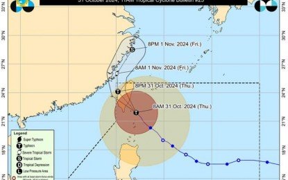
“It (Leon) continues to affect mostly Northern Luzon. Leon’s trough could possibly bring rains across the whole island,” Veronica Torres of the Philippine Atmospheric, Geophysical and Astronomical Services Administration (PAGASA) said in a briefing shortly before noon on Thursday.
Leon now has maximum sustained winds of 175 kph near the center and gustiness of up to 215 kph, and was located 155 kilometers north of Itbayat, Batanes as of 10 a.m. It had gustiness of 230 kph previously.
Gale force winds will be experienced in Babuyan Islands that is currently under TCWS No. 2.
PAGASA forecast strong winds in areas under TCWS No. 1: mainland Cagayan, Isabela, Apayao, Abra, Kalinga, Mountain Province, Ifugao, the northern portion of Benguet (Mankayan, Bakun, Buguias), Ilocos Norte, and Ilocos Sur.
PAGASA also forecast gale force winds to prevail in these areas due to Leon: most of Cordillera Administrative Region, Quirino, Nueva Vizcaya, Aurora, Bataan, Metro Manila, Calabarzon, Mimaropa, Bicol Region, Northern Samar and most of Western Visayas.
“Within the next 48 hours, there is a high risk of life-threatening storm surge with peak heights exceeding 3 meters above normal tide levels over the low-lying or exposed coastal localities of Batanes and Babuyan Islands,” PAGASA added.
Leon is forecast to make landfall over the eastern coast of Taiwan on Thursday afternoon, and exit the Philippine Area of Responsibility on Thursday night or Friday.
(IMAGE FROM PAGASA)